Predicting Floods and Protecting Lives
Hurricanes are among the deadliest weather phenomena on earth. Hurricane damages are usually associated with strong winds and other related impacts, including storm surge, rainfall-induced floods and tornadoes.
Hurricane intensity is often categorized using the Saffir-Simpson Hurricane Wind Scale, which ranges between 1 and 5. Hurricane Florence, a category 4 hurricane, hit the Carolinas in September 2018 and caused major flooding in coastal communities leading to 51 fatalities and damage estimates of around $25 billion. According the National Weather Service, certain locations in NC recorded over 30 inches of rain, exceeding the highest single-storm rainfall amounts ever seen in the state.
Given this extreme threat to human life, predicting major floods due to torrential rain is an urgent necessity. This, however, remains a challenge given the short time-scale of flooding combined with multiple uncertainties that limit the predictive capability of our water models. To tackle this, scientists in the Data Assimilation Research Section (DAReS), in collaboration with scientists in NCAR’s Research Application Lab (RAL) and the University of Texas at Arlington (UT Arlington) have recently developed a state-of-the-art ensemble prediction system that aims to increase the accuracy of flood forecasting during a hurricane landfall. The team coupled WRF-Hydro (the research compartment of the National Water Model; Gochis et al. 2020) with the Data Assimilation Research Testbed (DART; Anderson et al. 2009) and assimilated hourly streamflow data, collected from a hundred United States Geological Survey (USGS) gauges in the affected region. The framework uses 80 different streamflow realizations, incorporating multiphysics uncertainty and time-varying uncertainty in the forcing fluxes. The team also developed two novel data assimilation techniques that helped improve the prediction accuracy of the flood; namely, along-the-stream (ATS) localization and adaptive covariance inflation (Gharamti 2018). “ATS localization, which is a topologically-based updating scheme, helped reduce sampling errors for ungauged basins at specific sites such as the Rocky River near Norwood, NC” describes Dr. Gharamti from the DAReS team. He further adds “Adaptive inflation, on the other hand, was extremely useful at mitigating extreme model and boundary biases particularly near Pee Dee River in SC.”
Dr. McCreight from RAL really enjoyed the collaborative environment of this work adding “Having weekly meetings where there is an opportunity to look and investigate various hydrographs together, was indispensable for the success of the projects.” Concerning future plans, Dr. Gharamti said “Despite the success of this work, looking ahead we plan to further improve the assimilation framework by adding nonlinear streamflow updates that respect the non-Gaussian (positive) nature of the variable. This can be done by a statistical transformation, commonly referred to as Gaussian Anamorphosis.”
The team submitted their research to Hydrology and Earth System Sciences, a publication of the European Geophysical Union, where it is currently in review. The project was led by Moha Gharamti (DAReS) and James McCreight (RAL) and included contributions from Arezoo RafieeiNasab (RAL), Seong Jin Noh (UT-Arlington; now at Kumoh National Institute of Technology in South Korea), Tim Hoar (DAReS) and Ben Johnson (DAReS).
For more information, contact Moha El Gharamti by emailing gharamti@ucar.edu.
References
Anderson, J., Hoar, T., Raeder, K., Liu, H., Collins, N., Torn, R., and Avellano, A.: The data assimilation research testbed: A community facility, Bulletin of the American Meteorological Society, 90, 1283–1296, 2009.
Gharamti, M.: Enhanced adaptive inflation algorithm for ensemble filters, Monthly Weather Review, 146, 623–640, 2018.
Gochis, D., Barlage, M., Cabell, R., Dugger, A., Fanfarillo, A., FitzGerald, K., McAllister, M., McCreight, J., RafieeiNasab, A., Read, L., Frazier, N., Johnson, D., Mattern, J. D., Karsten, L., Mills, T. J., and Fersch, B.: WRF-Hydro® v5.1.1, doi.org/10.5281/zenodo.3625238, 2020.
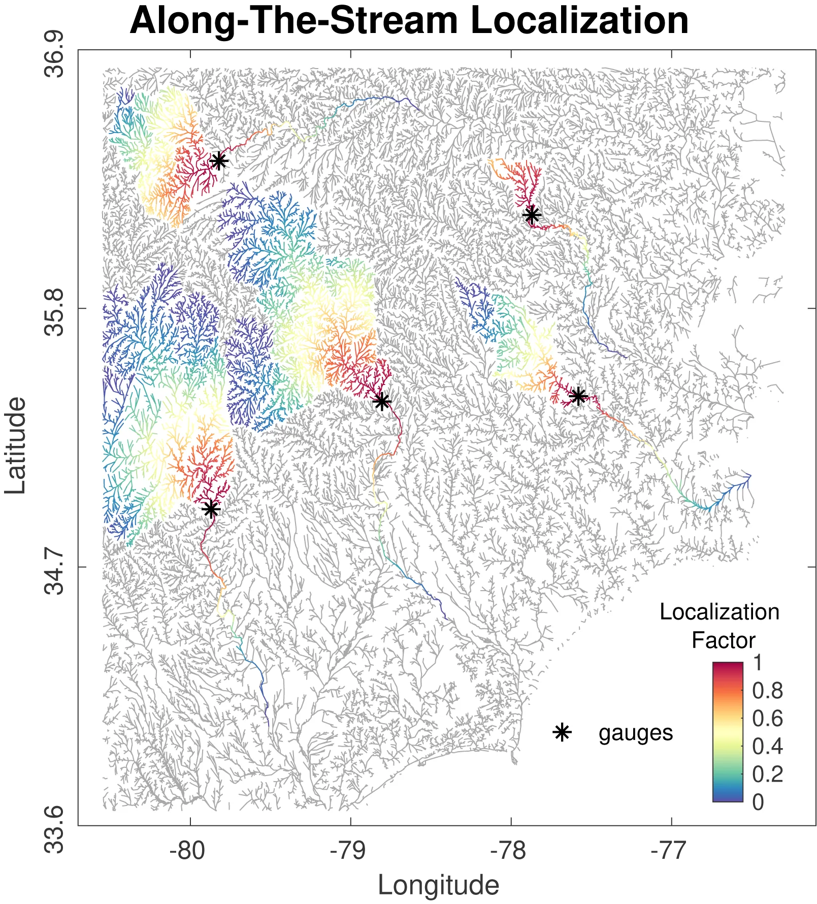
A depiction of the along-the-stream localization scheme implemented in the project. The asterisks depict stream flow gauges and the rainbow-colored segments depict the specific areas affected by the assimilated data.
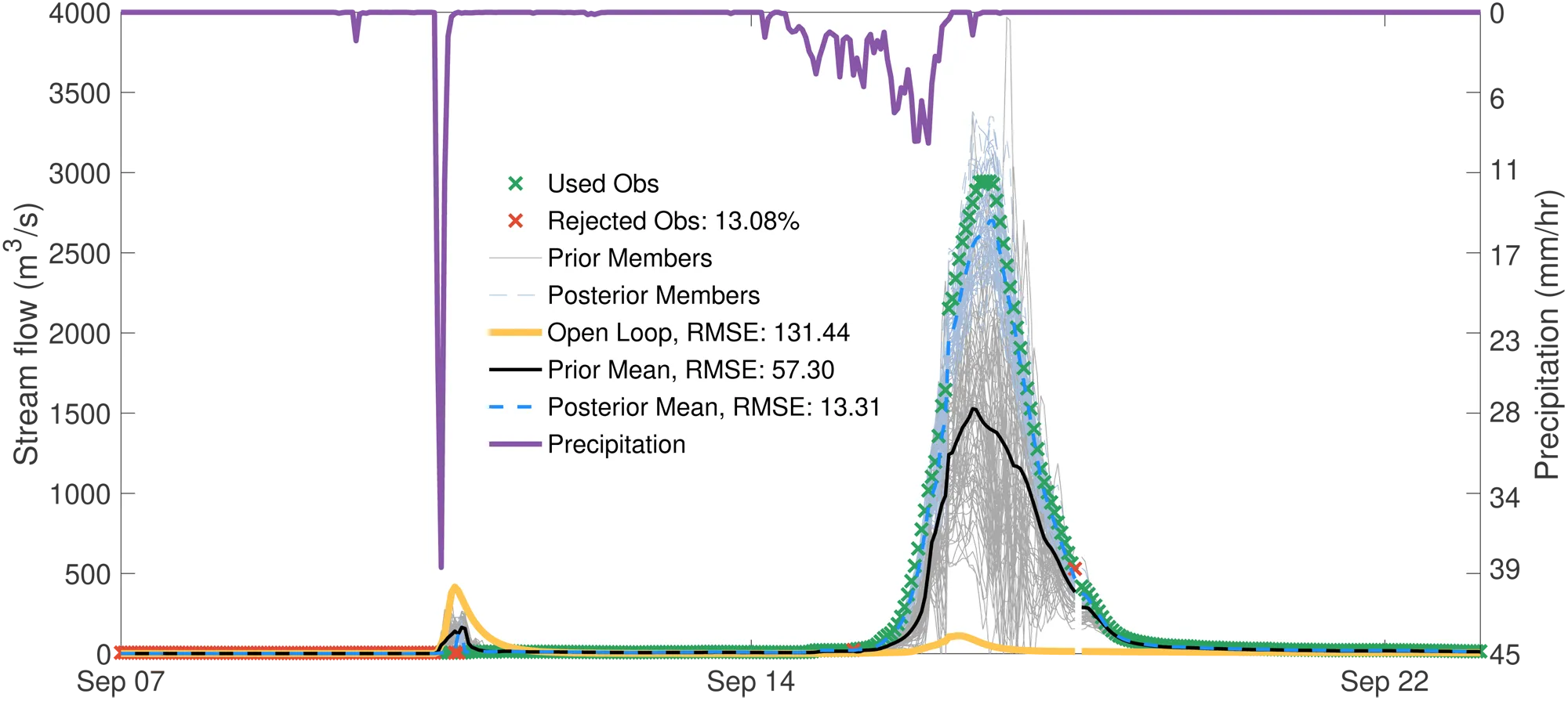
Precipitation and estimated stream flow for a hydrograph along the Pee Dee River. The Open Loop (orange line) refers to the estimated stream flow without data assimilation. The Prior (black line) and Posterior (dashed blue line) Means show significant reduction in the root mean squared error (RMSE).
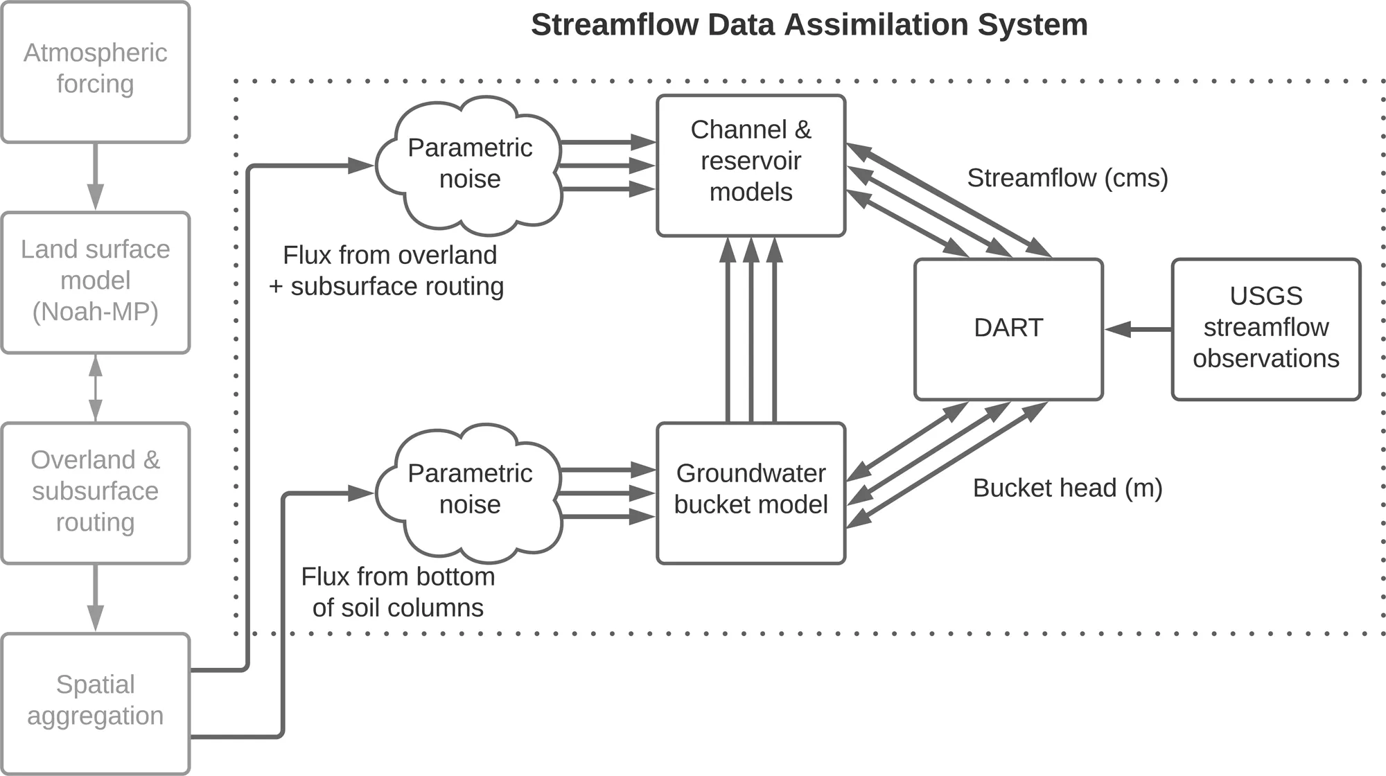
A schematic depicting the data assimilation system used in the experiment.